“Where the wheels hum, the lake glistens, and the forest breathes beside you.”
📖 Overview
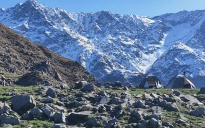
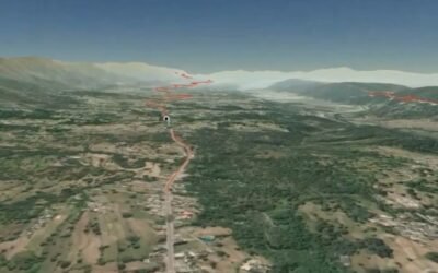
The Bhott–Gobind Sagar Trail is a 43.9-mile (70+ km) out-and-back route that begins from Bhott village, near Una, and winds along the Gobind Sagar shoreline. With 5,700+ ft of elevation gain, it’s a moderately challenging ride through lush green ridges, sal forests, and open lake vistas. While popular with mountain bikers, it’s also suitable for long-distance walkers and nature photographers looking for a low-traffic, high-reward trail.
🧭 Trail Profile
Attribute
Details
Trailhead
Bhott village (Una district)
Trail Type
Out-and-back loop
Distance
~70 km (43.9 miles)
Elevation Gain
~1,740 m (5,715 ft)
Duration
1 day (cycling) • 2–3 days (walking)
Grade
Moderate
Best Season
October–March
Permit Required
No (register locally for safety)
🌄 Trail Highlights
Gobind Sagar Vistas: Ride along serpentine ridgelines with mirror-like lake views, especially near Lathiani and Dholra.
Forest & Farmland Transitions: The trail weaves through sal and pine groves, village fields, and seasonal streams—ideal for birdwatching and botanical spotting.
Wildlife & Birdlife: Spot bar-headed geese, ruddy shelducks, lapwings, and jungle babblers—especially in winter months.
Quietude & Solitude: With low footfall, the trail offers a peaceful ride with occasional village interactions and forest silence.
🛕 Cultural & Ecological Touchpoints
Bhakra Dam Legacy: The trail skirts the Gobind Sagar reservoir, formed by the Bhakra Dam, one of India’s greatest hydropower projects.
Submerged Heritage: In winter, partially submerged temples may emerge—remnants of villages relocated during dam construction.
Village Life: Interact with locals in Bhott, Lathiani, and Dholra, where agriculture, fishing, and folk traditions thrive.
🧳 Essentials for Cyclists & Walkers
Item
Notes
Footwear
Cycling shoes or trail sneakers
Clothing
Layered; mornings cool, afternoons warm
Gear
Helmet, hydration pack, repair kit, binoculars
Food & Water
Carry essentials; refill in villages en route
Safety
Trail is safe; mobile signal may be patchy in forested zones
🧭 How to Reach
By Road:
Una ➝ Bhott: ~20 km
Chandigarh ➝ Una: ~120 km
Taxis and buses available from Una ISBT
By Train: Nearest railhead: Una Railway Station
By Air: Chandigarh Airport: ~110 km
🏞️ Add-On Adventures
Gobind Sagar Boating: Combine with a boat ride or birdwatching session near Lathiani or Bhakra ferry point
Naina Devi Temple Trek: A pilgrimage ascent above the lake with cable car option
Nadaun–Barsar Ridge Ride: Extend your cycling journey into Hamirpur’s pine ridges and cultural villages