“Where the desert meets the sky, and the moon rests on earth.”
📖 Overview
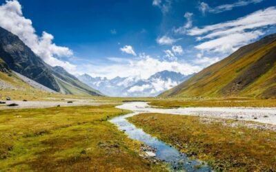
Perched at 4,300 meters (14,100 ft) in the Lahaul–Spiti district, Chandratal Lake—literally “Moon Lake”—is a glacial jewel nestled in the Samudra Tapu plateau near Batal. Once a stopover on ancient trade routes between Tibet and Kullu, today it’s a pilgrimage for trekkers, photographers, and solitude seekers. The trek offers a dramatic transition from rocky gorges to flower-carpeted meadows, with the Chandrabhaga peaks mirrored in the lake’s turquoise waters.
🧭 Trek Profile
Attribute
Details
Trailhead
Batal (via Manali or Kaza)
Lake Altitude
4,300 m (14,100 ft)
Trek Distance
~14–18 km (round trip from Batal)
Trek Duration
2–3 days
Grade
Easy to Moderate
Best Season
June to September
Permit Required
Yes (for foreigners; register at Batal or Kaza)
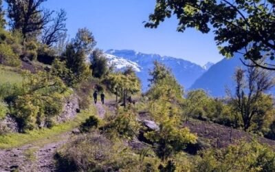
🥾 Trail Highlights
Batal to Chandratal: A scenic 7–9 km trail along the Chandra River, with views of CB13, CB14, and Mulkila peaks.
Moon Lake Magic: The lake’s crescent shape and color-changing waters (from sapphire to emerald) make it a photographer’s dream.
Wildflower Meadows: In spring, the lake’s banks bloom with blue poppies, primulas, and edelweiss.
Stargazing & Camping: With zero light pollution, Chandratal is one of the best places in India for Milky Way photography and meteor showers.
🛕 Cultural & Mythological Significance
Mahabharata Connection: Locals believe Yudhishthira ascended to heaven from here in his final journey.
Tibetan Influence: The lake lies on an old trans-Himalayan trade route, and nearby villages like Losar and Kaza reflect Buddhist culture.
Sacred Geography: Considered a tirtha (pilgrimage site) by locals—visitors often circle the lake in silent reverence.
🧳 Essentials for Trekkers
Item
Notes
Footwear
Trekking shoes with ankle support
Clothing
Sub-zero layers, windproof jacket, gloves
Gear
Headlamp, trekking poles, water purifier
Camping
Tents available ~5 km from lake (camping at lake is restricted)
Food
Carry your own or pre-arranged with trek operators
Safety
AMS risk above 4,000 m—acclimatize in Manali or Kaza
🧭 How to Reach
By Road:
Manali ➝ Rohtang ➝ Gramphu ➝ Batal (~120 km)
Kaza ➝ Kunzum Pass ➝ Batal (~70 km)
Roads open June–October; 4×4 recommended
By Train: Nearest railhead: Joginder Nagar or Chandigarh
By Air: Bhuntar Airport (Kullu): ~180 km from Batal
🏞️ Add-On Adventures
Baralacha La Trek: Extend to Baralacha Pass (4,890 m) via Tokpo Gongma and Tokpo Yongma
Spiti Circuit: Combine with Kaza, Key Monastery, Dhankar, and Pin Valley
Bara Shigri Glacier Viewpoint: En route from Kunzum Pass—Himachal’s largest glacier