“Where the Himalayas whisper old trade secrets to the sky.” 📖 Overview
The Parang La Trek is a 100–120 km high-altitude expedition that begins in Kibber (Spiti Valley) and ends in Korzok village on the banks of Tso Moriri Lake in Ladakh . Once a vital link on the Indo-Tibetan trade route , this trek crosses the Parang La Pass (5,538 m / 18,170 ft) and traverses glaciers, river valleys, and high-altitude plateaus . It’s a journey through geological drama , cultural silence , and sacred solitude —ideal for seasoned trekkers seeking a true Trans-Himalayan experience .
🧭 Trek Profile
Attribute Details Trailhead Kibber village (Spiti) Endpoint Korzok village (Tso Moriri, Ladakh) Pass Altitude 5,538 m (18,170 ft) Trek Distance ~100–120 km Trek Duration 10–12 days Grade Difficult (requires prior high-altitude experience) Best Season July to mid-September Permit Required Yes (Inner Line Permit for foreigners; forest entry for all)
🥾 Trail Highlights
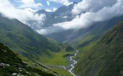
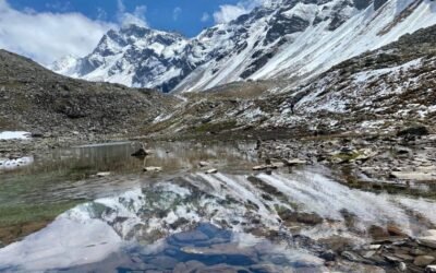
Kibber & Chicham Gorge: Chicham Bridge and Spiti’s deep canyons .Thaltak Meadows & Parang Glacier: alpine pastures , then cross the Parang Glacier , navigating crevasses and moraine fields .Parang La Pass: panoramic views of the Zanskar and Changthang ranges .Pare Chu River Valley: Pare Chu , a river that flows from India into Tibet and back—a rare hydrological loop .Tso Moriri Lake: crescent-shaped lake of Tso Moriri , home to bar-headed geese , kiangs , and Tibetan nomads .
🛕 Cultural & Historical Touchpoints
Ancient Trade Route: Silk Route , this trail connected Spiti’s wool and salt traders with Tibetan caravans .Korzok Monastery: Drukpa monastery overlooking Tso Moriri—spiritual anchor of the Changpa nomads .Sacred Geography: mani walls , prayer flags , and sky burial sites , reflecting deep Tibetan Buddhist roots.
🧳 Essentials for Trekkers
Item Notes Footwear High-ankle trekking boots (mandatory) Clothing Sub-zero layers, windproof jacket, gloves Gear Trekking poles, crampons (early season), headlamp Safety AMS risk above 4,500 m—acclimatize in Kaza or Kibber Support Local guide and porter strongly recommended Camping Tents at Thaltak, Norbu Sumdo, Dak Karzong, Kiangdom Water & Food Carry purification tablets; no villages en route
🧭 How to Reach
Start Point:
Manali ➝ Kaza ➝ Kibber (~220 km)Roads open June–October via Rohtang & Kunzum Pass
End Point:
Korzok ➝ Leh (~200 km) via Mahe Bridge Limited transport—private vehicle recommended
Nearest Airports:
Bhuntar (Kullu) for startLeh Airport for return
🏞️ Add-On Adventures
Tso Moriri to Tso Kar Traverse – For those continuing into Changthang Plateau Spiti Circuit – Combine with Key Monastery , Dhankar , and Pin Valley Wildlife Photography – Spot kiangs , Tibetan wolves , and migratory birds