“Where mustard fields sway, temples whisper, and the road meanders like a river.”
📖 Overview
The Una–Barsar Trail is a ~48 km point-to-point countryside route connecting Una town to Barsar (Hamirpur district). It traverses a patchwork of farmlands, pine ridges, seasonal streams, and village hamlets, offering a slow-travel experience through the Shivalik foothills. While often used by cyclists and off-roaders, it’s equally rewarding for long-distance walkers, rural photographers, and cultural explorers.
🧭 Trail Profile
Attribute
Details
Trailhead
ISBT Una (Himachal Pradesh)
Endpoint
Barsar town (Hamirpur district)
Distance
~47.9 km
Elevation Gain
~938 m
Duration (on foot)
2–3 days (with village halts)
Grade
Moderate (long but not technical)
Best Season
October–March
Permit Required
No (register locally for safety)
🌄 Trail Highlights
Village Life & Farmlands: Walk past wheat and mustard fields, mud homes, and temple courtyards, with opportunities to interact with local farmers and artisans.
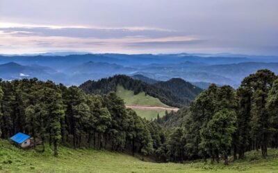
Forest Patches & Streams: The trail crosses sal and pine groves, seasonal nullahs, and ridge viewpoints with glimpses of the Dhauladhar range.
Cultural Touchpoints: Visit local shrines, folk deities, and village fairs if timed right—especially near Amb, Gagret, and Nadaun.
Birdwatching & Biodiversity: Spot hornbills, bee-eaters, lapwings, and jungle babblers along the quieter stretches.
🛕 Cultural & Historical Significance
Rural Devta Shrines: Small temples dedicated to local deities dot the trail—often under peepal trees or beside sacred ponds.
Folk Traditions: Villages along the route celebrate harvest festivals, naati dances, and seasonal melas—ideal for cultural immersion.
Oral Histories: Engage with elders who share stories of migration, partition, and land stewardship—a living archive of the region.
🧳 Essentials for Walkers
Item
Notes
Footwear
Comfortable walking shoes or trail sneakers
Clothing
Light layers; sun protection essential
Gear
Daypack, water bottle, camera, offline maps
Food & Stay
Dhabas en route; homestays or guesthouses in Una, Amb, Barsar
Safety
Trail follows roads in parts—reflective gear recommended
🧭 How to Reach
Start Point (Una):
Well connected by road and rail
ISBT Una is the trailhead
End Point (Barsar):
Connected to Hamirpur, Nadaun, and Kangra by road
Buses and taxis available for return
Nearest Airports:
Chandigarh Airport (~120 km from Una)
Gaggal (Kangra) Airport (~90 km from Barsar)
🏞️ Add-On Adventures
Gobind Sagar Lake Detour: Explore boating and birding near Lathiani or Bhakra
Nadaun Heritage Walk: Visit Nadaun Fort, temples, and river ghats
Barsar Ridge Extension: Continue towards Deotsidh Temple or Hamirpur’s pine trails