Above Narkanda, a narrow road climbs through dark deodar forest to a ridge where a wooden temple, a Pandava legend, and a long Himalayan horizon meet in the wind.
Hatu Peak is one of those places where the journey changes slowly. Narkanda’s small-town movement drops behind, the forest thickens, the road narrows, and the air begins to feel colder even before the summit appears. At the top, the land opens suddenly into a ridge of sky, temple bells, wind, and far snow ranges.
This is not only a viewpoint. Hatu Peak is also the seat of Hatu Mata Temple, a hilltop shrine held in deep local reverence. HPTDC identifies the temple as dedicated to Mandodari, the wife of Ravana, while local traditions also connect the peak with the Pandavas, especially through the stone formation known as Bhim Chulha. The result is a place where mythology, ridge-top geography, wooden temple architecture, and high-mountain travel all meet.
For many travellers, Hatu Peak is the finest half-day outing from Narkanda. For devotees, it is a sacred height. For walkers, it is a forest trail. For photographers, it is a snowline balcony. The peak holds all these meanings without needing to choose only one.
🌄 Location & How to Reach It
Hatu Peak is located near Narkanda in Shimla district, Himachal Pradesh. It rises above the Narkanda region at around 3,400 m / 11,150 ft, making it one of the highest and most striking accessible points in this part of Shimla district. The peak is surrounded by dense forests of deodar, spruce, fir, oak, and other Himalayan trees, and on clear days it offers wide views towards the higher Himalayan ranges.
Google Maps: Get Directions
Elevation: Around 3,400 m / 11,150 ft above sea level.
- By road: Hatu Peak is reached from Narkanda by a steep, narrow mountain road. Public and travel references usually give the distance as around 6–8 km from Narkanda, depending on whether one refers to the road route or walking trail. The road is very narrow in places, so local driving experience is useful.
- By trek: Many visitors walk from Narkanda to Hatu Peak through forest. The trek is commonly described as around 7 km one way, depending on the starting point and route taken.
- By rail: The nearest broad-gauge railway access is Kalka, followed by road travel through Shimla and Narkanda. The Kalka–Shimla toy train can also be used up to Shimla, followed by road travel.
- By air: The nearest airport is Shimla Airport at Jubbarhatti, though many travellers use Chandigarh Airport for better connectivity and continue by road.
The peak is not a difficult expedition, but it should not be treated casually either. The road is narrow, the weather changes quickly, and snow can affect access in winter.
🌸 Best Time to Visit
The best time to visit Hatu Peak is generally April to June and September to November. These months offer better road access, clearer skies, forest walks, and a good chance of mountain views.
Spring and early summer bring pleasant weather around Narkanda, though afternoons may still turn windy at the top. Autumn is often excellent for long-distance visibility, especially after the monsoon haze has cleared. Winter can be beautiful, with snow around Narkanda and Hatu Peak, but the road may become slippery or blocked. In heavy snow, only experienced local drivers should attempt the route, and sometimes walking may also become difficult.
Monsoon months bring mist, leeches in some forest stretches, slippery trails, and reduced views. The forest becomes lush, but the summit may remain covered in cloud.
Morning is the best time to visit. The sky is usually clearer, traffic is lighter, and the temple atmosphere is quieter. By afternoon, wind, cloud, and crowd movement can increase.
🕉️ Hatu Mata and the Mandodari Tradition
Hatu Mata Temple is the sacred centre of Hatu Peak. HPTDC describes the temple as dedicated to Mandodari, the wife of Ravana. This makes the shrine unusual, because Mandodari is not commonly the central deity of temples in North India.
In the Ramayana tradition, Mandodari is remembered as Ravana’s queen — wise, restrained, and often portrayed as a voice of caution in Lanka. She is not shown as a villainous figure. In many retellings, she is dignified, perceptive, and morally aware, even while bound to the tragic fate of Ravana’s kingdom.
At Hatu Peak, her worship takes on a local form as Hatu Mata. The goddess is not approached through courtly Lanka alone, but through a Himalayan ridge, deodar forest, wooden architecture, and local devotion. This is how mountain religion often works. A figure from epic tradition becomes rooted in a specific place, gaining a local name, local rituals, and a local presence.
The shrine therefore deserves to be understood carefully. It is not simply a “Ravana-related temple.” It is a local goddess temple where Mandodari’s memory has been absorbed into the sacred landscape of Narkanda.
🏛️ A Wooden Temple on a Windy Ridge
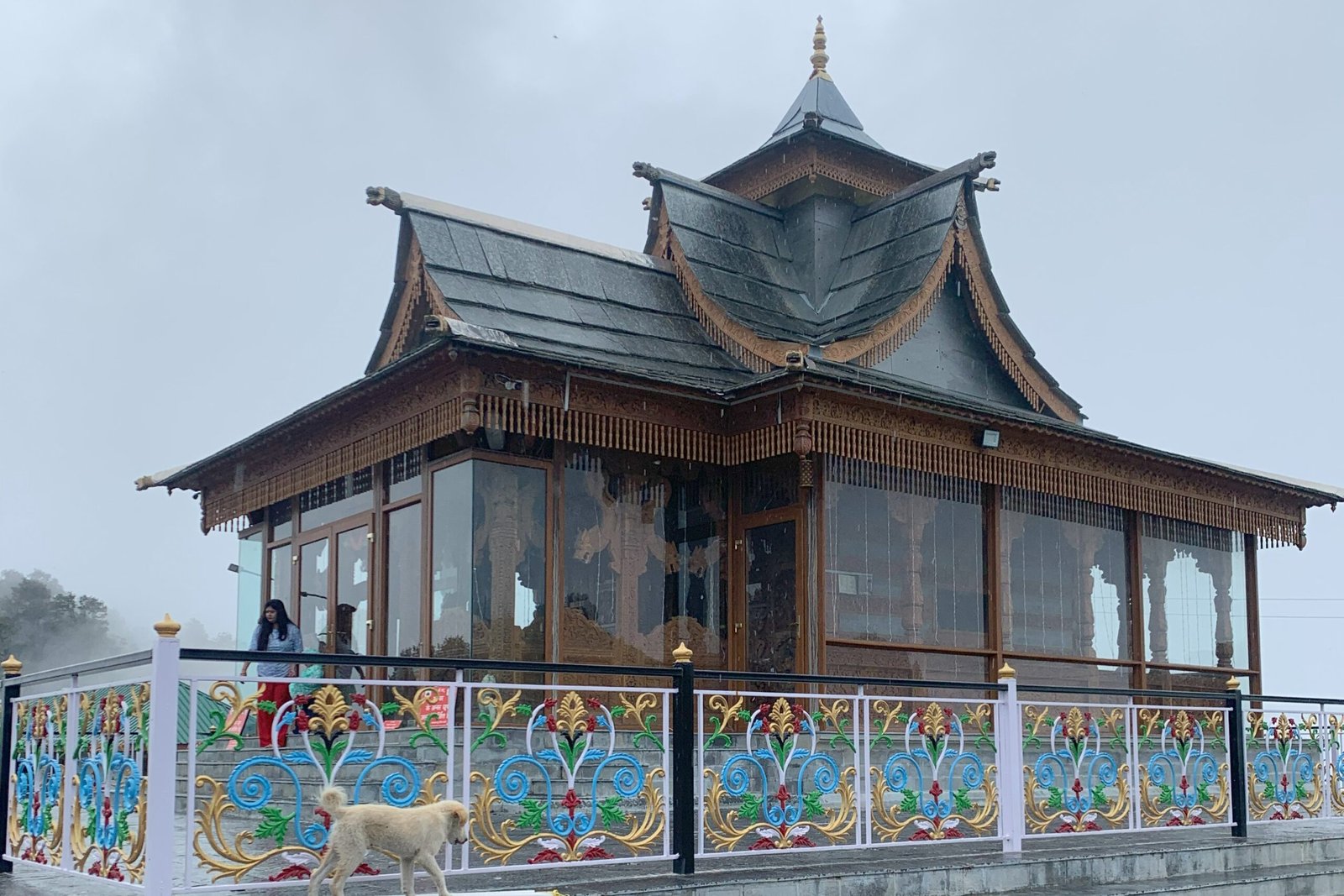
Hatu Mata Temple is one of the most visually striking features of the peak. The temple uses a Himalayan wooden style, with carved panels, a sloping roof, and a mountain form that suits the ridge-top climate. Unlike plains temples built for dry heat, this structure responds to snow, wind, and cold.
The woodwork gives the shrine warmth. The carvings hold the eye. The roofline sits against the sky. On a clear day, the temple appears almost like a wooden ark resting above the forest.
The temple’s position matters as much as the building itself. It stands at the summit, where the forest finally opens and the horizon widens. The visitor reaches it after a narrow road or a long forest walk, so the darshan feels earned. Even those who come mainly for the view often fall silent near the shrine.
Inside and around the temple, the atmosphere is simple. Bells, carved wood, mountain wind, and prayer flags or cloth offerings create a sacred mood without needing exaggeration. The stone holds cold; the wood holds touch; the ridge holds the sky.
🔥 Bhim Chulha and the Pandava Memory
Near Hatu Peak, visitors often hear about Bhim Chulha, a pair or group of large stones associated with the Pandavas. Local tradition says the Pandavas stayed in this region during their exile, and Bhim used these stones as a cooking place.
This legend is common in Himalayan sacred geography. Across Himachal, Uttarakhand, and other mountain regions, places are linked with the Pandavas through caves, stones, meadows, temples, and routes. These stories do not function as archaeological proof in the modern sense. They work as sacred memory, giving moral and mythic meaning to the landscape.
At Hatu, the Pandava story fits naturally. The ridge feels old enough for exile. The stones feel large enough for Bhim. The forest has the silence of a place where epic figures could pass unseen.
Bhim Chulha also gives the peak a human warmth. Hatu Mata Temple carries goddess devotion; the summit carries mountain grandeur; Bhim Chulha adds the image of travellers cooking in exile. It turns the peak from a viewpoint into a remembered shelter.
🙏 What Hatu Peak Is Known For
Hatu Peak is known for three things at once: Hatu Mata Temple, the Himalayan views, and the forest approach from Narkanda.
Devotees visit the temple for blessings from Hatu Mata, local protection, and traditional worship. Travellers come for the summit views, especially towards the snow-covered ranges on clear days. Walkers come for the route through dense forest. In winter, the area is also loved by those who want snow around Narkanda.
The peak is one of the best short mountain experiences from the Shimla–Narkanda belt because it offers a strong sense of height without requiring a long expedition. It can be done as a short drive, a day walk, or a slow half-day outing.
But the peak should not be reduced to a picnic point. Its temple, legends, and local reverence give it a different depth. The summit belongs to the goddess first, then to the camera.
🌲 The Forest Road From Narkanda
The road from Narkanda to Hatu Peak is part of the experience. It climbs through thick forest, with tight bends, shaded patches, and narrow sections where careful driving is essential. In many places, two vehicles cannot pass easily. Visitors not used to hill driving should hire a local taxi or driver from Narkanda.
Walking is the slower and often more memorable way to reach the peak. The trail passes through conifer forest, with changing light, bird calls, and occasional openings towards the valley. It is not a technical trek, but the altitude and gradient can make it tiring for those not used to walking.
In winter, snow changes everything. The road may become risky, the trail may be covered, and fog or cloud can reduce visibility. In monsoon, the forest is beautiful but slippery. Good shoes, water, and layered clothing are sensible even on a short visit.
Hatu Peak rewards patience. The road is not just a means of transport; it is a gradual leaving behind of the lower world.
📜 Narkanda, Apple Country, and the Old Hindustan-Tibet Route
Hatu Peak also helps explain the importance of Narkanda. Narkanda stands on the old Shimla–Rampur–Kinnaur route, part of the wider historic corridor often associated with the old Hindustan-Tibet road system. It has long been a high resting point between the Shimla hills and the upper Satluj side.
Today, Narkanda is also known for apple orchards, winter snow, skiing slopes, and its role as a quieter alternative to Shimla. Hatu Peak rises above this landscape like a natural watchtower.
From the summit, one can understand why such heights mattered. They give visibility, orientation, and a sense of connection between valleys. The view is not only scenic; it is geographic. Forest, orchard, ridge, snowline, and road all come into one frame.
The temple at the top gives that geography a sacred centre. Without the temple, Hatu would still be a beautiful peak. With the temple, it becomes a place of memory.
🎉 Festivals and Devotion
- Local Hatu Mata worship: Devotees visit the temple for blessings from Hatu Mata, locally associated with Mandodari.
- Navratri: As a goddess shrine, Navratri is a meaningful time for worship, though local arrangements should be confirmed before planning a festival visit.
- Village and regional devotion: The temple is important to people from Narkanda and surrounding areas, not only to tourists.
- Bhim Chulha visit: Many visitors combine temple darshan with a short visit to the Pandava-linked stones known as Bhim Chulha.
- Respect at the summit: The peak may attract travellers for views, but the temple area should be treated as a sacred space. Avoid loud music, littering, or casual behaviour near the shrine.
🏞️ While You’re in the Area
- Narkanda: The natural base for Hatu Peak, known for apple orchards, winter snow, local markets, and access to nearby forest walks.
- Tani Jubbar Lake: A small lake near Narkanda, often visited with the local Nag Devta temple and surrounding deodar scenery.
- Stokes Farm / Thanedhar: Connected with the history of apple cultivation in Himachal, especially through Samuel Evans Stokes.
- Kotgarh: A historic apple-growing region near Narkanda, useful for understanding the orchard culture of upper Shimla district.
- Jau Baug: A meadow area near Hatu Peak, often visited by walkers and nature lovers.
- Narkanda Ski Slopes: In winter, Narkanda is known for skiing and snow activities when conditions allow.
- Rampur Bushahr: A historic town on the Satluj side, useful for travellers continuing towards Kinnaur.
🙏 Getting in Touch
There is no widely verified official temple office, booking system, or public contact number available for Hatu Mata Temple in common public sources. For current road condition, snow access, temple opening, taxi availability, and local worship information, ask in Narkanda before starting.
If travelling in winter, do not rely only on maps. Check with local taxi drivers, hotel staff, or residents about whether the Hatu road is open and safe. During snow or ice, local driving experience matters.
As with all living shrines, remove shoes where required, avoid touching sacred objects, keep the temple area clean, and ask before photographing inner spaces or the deity.
❓ Quick Questions Travellers Ask
Where is Hatu Peak located?
Hatu Peak is located near Narkanda in Shimla district, Himachal Pradesh.
How high is Hatu Peak?
Hatu Peak is commonly given at around 3,400 m / 11,150 ft above sea level.
How far is Hatu Peak from Narkanda?
Most sources describe it as around 6–8 km from Narkanda, depending on the road route or trekking route.
Which temple is on Hatu Peak?
Hatu Mata Temple is located at the summit of Hatu Peak.
Who is Hatu Mata?
HPTDC identifies Hatu Mata with Mandodari, the wife of Ravana. Local worship treats her as the presiding goddess of the peak.
What is Bhim Chulha?
Bhim Chulha is a group of large stones near Hatu Peak, linked by local tradition with the Pandavas and Bhim’s cooking place during exile.
Can cars go to Hatu Peak?
Yes, vehicles can go by road in suitable weather, but the road is narrow and steep. Local drivers are recommended.
Can Hatu Peak be done as a trek?
Yes. Many visitors trek from Narkanda through forest. The walk is usually described as around 7 km one way, depending on the start point.
What is the best time to visit Hatu Peak?
April to June and September to November are generally best for road access and views. Winter is beautiful but depends on snow conditions.
Are photos allowed inside Hatu Mata Temple?
Photography rules may depend on temple custom. Ask before photographing the inner sanctum or deity.
A Last Word
Hatu Peak is not only a high point above Narkanda. It is a ridge where several kinds of memory meet. The goddess sits at the top. The Pandavas pass through the stones. The forest holds the road in shadow. The snow ranges appear and disappear with the weather.
A traveller may come for the view and still leave remembering the temple. A devotee may come for Hatu Mata and still pause before the vast horizon. That is the quiet strength of the place.
At Hatu, the climb is short, but the feeling is wide. The summit gives Narkanda its sacred height — wooden temple, cold wind, forest below, and the Himalaya opening beyond.
Fact-check note: Hatu Peak is consistently identified as a high summit near Narkanda in Shimla district, commonly placed around 3,400 m / 11,150 ft above sea level. HPTDC confirms that Hatu Mata Temple rests on Hatu Peak and identifies the deity with Mandodari, wife of Ravana. Public sources vary on the exact distance from Narkanda, generally giving around 6–8 km depending on road or walking route, so this article uses a cautious range. The Bhim Chulha and Pandava association are treated as local sacred tradition rather than archaeological proof. Road access, snow conditions, and temple access can change seasonally, so visitors should confirm locally in Narkanda before travelling, especially in winter or during bad weather.