Somewhere past 12,000 feet, where the air thins and the silence gets a texture you can almost touch, a small wooden shrine to Krishna stands beside a glacial lake that pilgrims believe the Pandavas themselves dug into the mountain
Most Krishna temples in India sit at the centre of a town, easy to reach, busy with daily footfall. Yulla Kanda is the opposite of all of that. Reaching it means a genuine multi-day trek through Kinnaur’s Rora Valley, climbing well past the treeline into terrain so remote that locals still cross a 4,800-metre pass on foot just to attend its one major festival each year. What waits at the end is widely described, without much argument from anyone who’s made the climb, as the highest Krishna temple in the world — a modest wooden shrine standing at the edge of a lake so still it mirrors the peaks around it.
🌄 Location & How to Reach It
- Location: Yulla Kanda, Rora Valley, Nichar Tehsil, Kinnaur District, Himachal Pradesh
- GPS Coordinates (temple/lake): 31.5906° N, 78.1408° E
- GPS Coordinates (Yulla Khas, trailhead village): 31.5657° N, 78.1308° E
- Google Maps (temple): Get Directions
- Google Maps (Yulla Khas village): Get Directions
- Altitude: Approximately 3,895 metres (12,778 feet) — some sources round this to 12,000 or 12,500 feet, a normal variance for remote high-altitude sites without formal survey markers
- Trek Distance: Most sources list roughly 12 km one way from Yulla Khas village (22–24 km round trip), though at least one detailed visitor account measures it closer to 9 km one way (18 km round trip) taking about 6 hours from the main road — a reasonable spread given how informally this trail is measured
- Trek Duration: Typically 3–4 days including acclimatization and return
The route from Delhi/Chandigarh: The journey runs via Shimla, Narkanda, Rampur Bushahr, and Tapri, following NH-5, the historic Hindustan-Tibet Road, before a short onward drive or local transport to Yulla Khas village, the trek’s actual starting point, near Urni in Kinnaur. Worth flagging directly: a few lower-quality travel sites describe reaching Yulla Kanda via Mandi, Kullu, or Bhuntar Airport — this is incorrect and would take you in entirely the wrong direction. The correct approach is firmly via Shimla and the Sutlej Valley route through Rampur and Tapri, not through Kullu district at all.
A typical itinerary: Most trekking groups spend a first night in Yulla Khas, acclimatizing and enjoying the village’s Kinnauri hospitality and locally grown apples, before setting out early the next morning. The 12 km climb passes through dense forest and open alpine meadow, often broken into two stages with a base camp roughly 4 km in, where basic tented accommodation (reportedly around ₹1,200 per person including meals) is available during the trekking season. From there, a further push — sometimes with an additional short camp closer to the lake — brings trekkers to Yulla Kanda itself, typically on the second or third day, with the return journey completing the trip on day three or four.
A genuinely useful practical note: recent visitors report refreshment points roughly every 1–2 km along the trail, making it easier to break the climb into manageable stages rather than pushing through in one continuous effort. Several accounts also specifically flag the final 1–1.5 km stretch beyond the last base camp as the most difficult and, for some, genuinely unnerving part of the trek — steep and demanding enough that it’s not recommended for anyone with underlying health issues, even though the reward at the top is consistently described as making the effort worthwhile.
Getting to the wider area: The nearest railhead is Shimla, connected to Kalka by the narrow-gauge Kalka-Shimla line, with onward road travel of around 200 km to Tapri. This is genuinely remote Kinnaur terrain, and the journey itself — through Narkanda’s apple orchards and the dramatic Sutlej gorge beyond Rampur — is very much part of the experience rather than simply a means of getting there.
🌸 Best Time to Visit
Mid-May to mid-October is the firm consensus across every source on this trek, and for good reason: this is a genuinely high-altitude site where snow closes the route entirely through winter and much of spring. Within that window, late May to June brings rhododendron blooms and comfortable daytime temperatures, ideal for photography and for beginners or families attempting the trek. July to August (monsoon) is best avoided — heavy rain, slippery trails, and leeches make this the least favourable stretch of the season despite falling within the technically “open” months. September to October offers the clearest skies and most comfortable trekking conditions of the year, with golden autumn light across the meadows. The single most important date on the calendar, though, is Janmashtami, when the temple becomes the focus of a major regional pilgrimage.
Temple access: Open throughout the trekking season; effectively closed and inaccessible once winter snow sets in, typically from November through April.
🕉️ A Lake the Pandavas Are Said to Have Dug
Local legend holds that the Pandavas, during their years of exile, created the sacred lake at Yulla Kanda and built a shrine here to honour Krishna — their guide, friend, and protector throughout the Mahabharata. Some tellings go further, describing the site as a place where Krishna revealed a glimpse of his cosmic, universal form to sages meditating in solitude, and some local accounts describe the temple’s deity as swayambhu — self-manifested, rather than carved and installed by human hands. As with most such legends, there’s no way to verify a precise founding date, and local elders themselves generally describe the temple’s age simply as “centuries,” maintained through devotion rather than grand patronage or written record.
What is more concretely documented is the origin of the site’s major festival: according to tradition, it was the Bushahr king Kehari Singh who first initiated the Janmashtami fair here, a practice that continues today largely unchanged. Each year, hundreds of devotees from Kalpa, Pangi, and neighbouring villages make the demanding crossing over the Kashang Pass (4,800 metres) specifically to attend, accompanied on the way by both Hindu ritual and, reflecting Kinnaur’s genuinely syncretic religious culture, Buddhist lamas performing their own rites alongside them — chanting, folk singing, and shared celebration marking the whole journey rather than just the destination.
One local custom stands out as particularly distinctive: pilgrims traditionally float a Kinnauri cap, placed upside down, on the surface of the lake. If the cap crosses to the far shore without sinking, it’s taken as a sign that the coming year will bring peace and good fortune; if it sinks along the way, it’s read as a warning to tread more carefully in the months ahead. Some traditions also hold that circling the lake on foot serves as an act of atonement for past wrongdoing — a quiet, physical ritual rather than anything more elaborate.
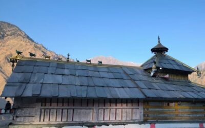
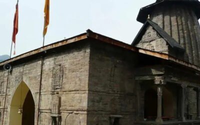
🏛️ A Shrine Built for Altitude, Not Grandeur
There’s deliberately little architectural ambition here, and that’s rather the point. The temple is a simple wooden and stone structure, built in traditional Himachali style, standing on what several accounts describe as a small rocky rise within or immediately beside the lake itself. The Krishna idol inside is modestly adorned — flowers and woollen shawls wrapped around it against the genuinely severe cold of this altitude — and prayer flags mark the site rather than elaborate carving or ornamentation. What draws people here isn’t craftsmanship; it’s the setting itself: a glacial lake reflecting snow-capped peaks, forests of Bhojpatra (Himalayan birch, historically used as a writing material for ancient scriptures) giving way to open meadow, and a silence that multiple visitors specifically describe as unlike anywhere else they’ve trekked in Himachal.
🎉 Festivals and the Rhythm of Devotion
- Janmashtami: By far the temple’s most significant occasion, drawing devotees from Kalpa, Pangi, and Ribba across the demanding Kashang Pass route, with the Kinnaur district administration now organising it as a district-level celebration.
- Daily worship (in season): Simple offerings of water, flowers, and quiet presence rather than elaborate ritual — this remains fundamentally a pilgrimage site defined by effort and altitude rather than daily ceremonial life.
🏞️ While You’re on the Trek
- Rora Kanda: A striking high-altitude meadow about an hour’s walk northeast of Yulla Kanda, at roughly 3,900 metres, popular for camping and stargazing with views toward the Buran and Listigarang passes.
- Kashang Pass (4,800m): The demanding route connecting Kinnaur to Pangi village, traditionally used by pilgrims attending the Janmashtami festival.
- Listigarang Pass: Northwest of Yulla Kanda, part of the wider trekking network connecting toward Kafnu village and the Bhabha Valley.
- Kinner Kailash Range: Visible in panorama from much of the trek, adding a second layer of Himalayan grandeur to the Krishna pilgrimage itself.
- Yulla Khas village: Worth a proper stay rather than a rushed overnight — known locally for its Kinnauri apples and genuinely warm hospitality.
🙏 Getting in Touch
There’s no formal contact number or booking system for the temple itself — it’s a remote pilgrimage site rather than a managed attraction. For trek arrangements, most visitors book through local guides or homestay operators in Yulla Khas or via trekking agencies operating out of Shimla and Rampur; hiring a local guide is widely recommended both for safety and to properly navigate the route’s altitude and stream crossings.
❓ Quick Questions Travellers Ask
Is this really the highest Krishna temple in the world? It’s very widely described that way across trekking guides, local tradition, and travel documentation, making it the standard claim associated with the site — though, as with similar “highest in the world” titles elsewhere, it’s worth treating as the commonly accepted claim rather than something independently, exhaustively audited against every possible rival site.
How difficult is the trek? Generally rated easy-to-moderate — steady ascents through forest and meadow rather than technical climbing, but the altitude (nearly 3,900 metres) means acclimatization genuinely matters, and the final stretch to the temple is notably steep.
Do I need a guide? Strongly recommended, particularly given the altitude, stream crossings, and the trail’s relative remoteness compared to more established Himachal treks.
What should I pack? Warm layered clothing regardless of season, waterproof footwear, a sleeping bag if camping, high-energy snacks, water purification, and a basic medical kit — standard high-altitude trekking essentials, with genuinely cold nights even in peak summer.
Can this be combined with other Kinnaur sightseeing? Yes — most itineraries build in time in Kalpa, Sangla, or Rampur Bushahr either before or after the trek, making it easy to fold into a longer Kinnaur circuit rather than a standalone trip.
A Last Word
There’s something quietly humbling about a god whose most celebrated shrine requires days of walking and a genuine test of altitude to reach. No road brings you here, no easy darshan waits at the end of a short car journey — just forest, then meadow, then thinning air, and finally a small wooden temple standing at the edge of water so still it seems to hold the whole sky inside it. Whatever brought the Pandavas to this exact lake, according to the story this place still tells about itself, it’s hard to stand here and not understand, at least a little, why they might have chosen to stop.
Fact-check notes: The earlier draft of this article, published on the site, was factually accurate but written in a dense, bullet-fragment style rather than connected narrative prose; this rewrite restructures the same verified information into fuller storytelling while adding previously omitted practical detail (a realistic day-by-day trek itinerary, nearby meadows and passes, camping cost estimates, and packing guidance). One widely circulated online source describing access to Yulla Kanda via Mandi, Kullu, and Bhuntar Airport was identified as incorrect and has been explicitly corrected here — the actual route runs via Shimla, Narkanda, Rampur, and Tapri, entirely within the Sutlej Valley rather than through Kullu district. The founding king’s name is standardised here as Kehari Singh, per the majority of sources, noting minor transliteration variance (some sources render it “Kehri Singh”). As with most remote pilgrimage legends, the temple’s exact founding date cannot be independently verified, and this is presented honestly rather than assigned a specific era.