
Hydropower & River Projects
Sawra Kuddu Hydroelectric Project, Shimla
A piano-key weir and a 111 MW station on the Pabbar
At a glance
- Location
- Sawra and Snail, Rohru area, Shimla district
- How to reach
- Via Rohru and the Pabbar valley road
- Walking difficulty
- Public approaches and designated viewpoints
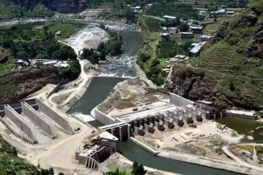
On the Pabbar, HPPCL’s Sawra Kuddu scheme uses a distinctive folded weir at the diversion and generates power underground near Snail.
🌄 Location and how to reach it
The project lies in Shimla district in the Rohru area. Use Rohru as the transport base and clarify which public point on the Pabbar you want to reach. Sawra, the diversion works and the power-house area near Snail are different locations.
Google Maps: Map the approach
- By road: Approach through the Rohru side and check the local road to Sawra before leaving town. Stop only where you can leave the road clear.
- By public transport: Ask at Rohru about buses or shared rides for the section of the valley you intend to visit. Confirm your pickup as well as the outward stop.
- On foot: Use village lanes and public crossing points. Do not approach the weir, intake or outlet without the operator’s authorisation.
🎹 Why the weir has a folded crest
A piano-key weir folds the overflow crest back and forth. This lengthens the edge over which water can pass within the width of the river structure. At Sawra, an intake diverts part of the Pabbar through desilting works before water enters the tunnel.
⚙️ Below the hillside at Snail
An approximately 11 km headrace and an underground pressure system deliver water to three 37 MW vertical-axis Francis machines, for 111 MW. Because both the waterway and the power house are largely underground, the most distinctive above-ground structure is the diversion.
🌊 The Pabbar’s place in the basin
The Pabbar belongs to the Tons–Yamuna drainage. Many large Himachal projects use the Sutlej, Ravi or Beas. Sawra Kuddu illustrates how a hydropower scheme uses elevation and flow in a different part of the state’s river network.